
What happens when a high-value asset moves beyond cellular coverage, but the next operational decision still depends on knowing where it is? Satellite tracking for remote assets can keep location and monitoring data moving from isolated equipment to the teams responsible for it. But a satellite link alone doesn’t create useful visibility.
Remote equipment can be difficult to locate consistently, and gaps in monitoring can delay maintenance and operational decisions. The value comes from designing the full data path: a tracker captures information, satellite connectivity carries it, and a platform presents it in a form operations teams can use. Each part must fit the asset, coverage conditions, reporting needs, and response workflows.
This article explains how satellite asset tracking works, where it fits alongside cellular and LoRaWAN, and which practical choices shape a deployment. It also covers challenges such as power use, data transmission, and integration, with practical ways to address them. NET WIZARDS’ Satellite Asset Tracker supports an integrated monitoring architecture that can inform operational efficiency, predictive maintenance, and safety planning.
Key Takeaways
- Satellite tracking for remote assets depends on a complete data path, from asset telemetry through connectivity and platform processing to operational action.
- Choose connectivity according to where equipment operates, how it moves, the data it needs to send, and the infrastructure already in place.
- Plan for practical constraints such as power, data frequency, integration, and clear ownership of operational responses.
- Use satellite asset tracking as part of an integrated monitoring architecture, not as a standalone solution.
- NET WIZARDS L.L.C supports continuous real-time monitoring of high-value mobile and remote equipment, with solution delivery spanning sensor design, cloud integration, and analytics.
Table of Contents
- Satellite Tracking for Remote Assets & When to Use It
- How Satellite Tracking Moves Data from a Remote Asset to Operations
- Satellite, Cellular, or LoRaWAN: Which Connectivity Role Fits the Asset?
- Remote Asset Tracking Challenges and Practical Design Responses
- How NET WIZARDS Integrates Satellite Asset Tracking into Industrial Monitoring
Satellite Tracking for Remote Assets & When to Use It
Satellite tracking for remote assets uses a tracking device to capture location and other asset information, then sends that data through satellite connectivity to a receiving system. It helps operators maintain visibility when equipment works beyond dependable terrestrial network coverage. The satellite link is one part of the arrangement, not the complete tracking workflow.
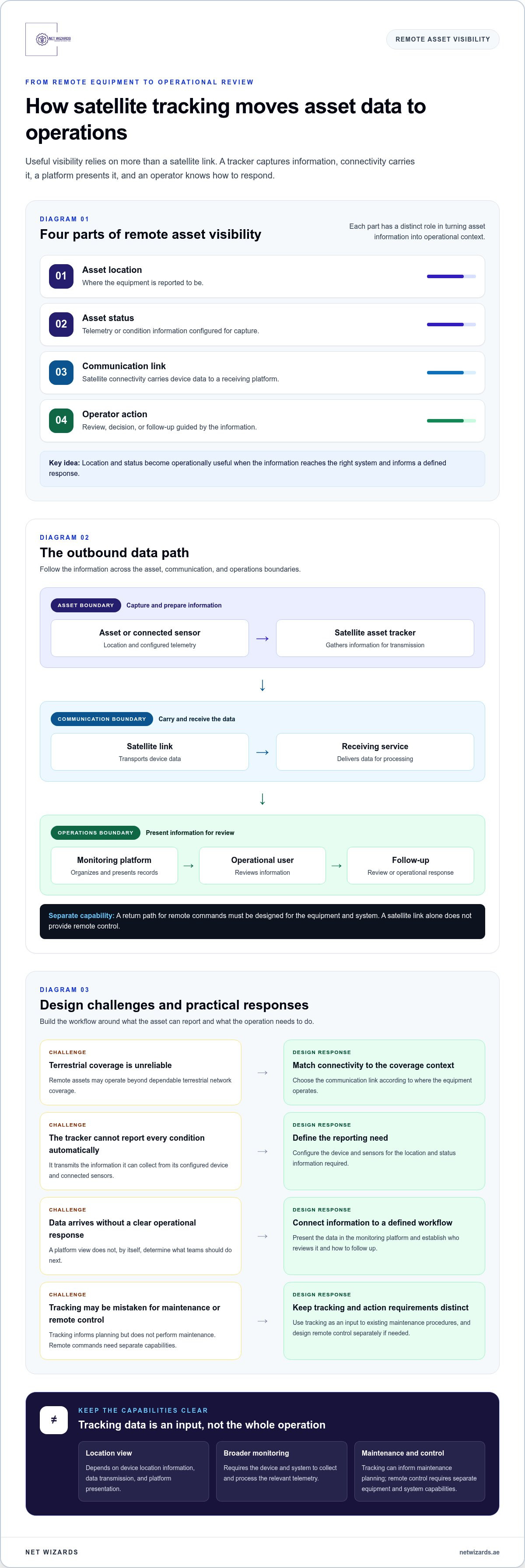
Useful visibility depends on four connected elements: the device captures relevant information, a suitable communication link carries it, a platform handles and presents the data, and an operator knows how to respond. The fundamentals of satellite communication help explain how data can travel between remote equipment and a receiving system. The tracking application determines what that data means operationally.
Infographic: Four parts of remote asset visibility
- Asset location: Where the equipment is reported to be.
- Asset status: The telemetry or condition information the device is configured to capture.
- Communication link: The satellite connection carrying device data to a receiving platform.
- Operator action: The review, decision, or follow-up guided by the information.
Location and status become operationally useful when the information reaches the right system and informs a defined response.
Which remote asset problems can satellite tracking address?
Routine site visits may not provide timely visibility of mobile equipment or infrastructure spread across remote operating environments. Examples include machinery used away from a fixed facility, vehicles travelling through areas with limited terrestrial coverage, and equipment supporting critical infrastructure. When teams cannot readily establish an asset’s location or review its telemetry, they have less information for dispatch, maintenance planning, or asset oversight.
A tracking system helps close that information gap by transmitting configured location and status data for review. It doesn’t replace inspections or maintenance procedures. Instead, it gives teams another input for deciding which asset needs attention and when to investigate further.
What satellite tracking does and does not mean
Satellite connectivity carries data from a device; it doesn’t, by itself, define the tracking workflow. A location view depends on the device’s location information, data transmission, and the platform’s ability to present the result. Broader remote monitoring may include additional telemetry, when the device and system are designed to collect and process it.
Remote control is a separate function. It requires suitable control capabilities in the equipment and supporting system, not merely a satellite link. Tracking data can inform maintenance planning, but it doesn’t perform maintenance or determine the response on its own. Design for the required coverage context, reporting needs, and operational process, and account for the conditions that can affect updates.
How Satellite Tracking Moves Data from a Remote Asset to Operations
A satellite tracking system is a chain of components, each with a defined role. The asset produces or carries information, the tracker gathers and prepares it for transmission, satellite communication transports it, and a receiving platform organizes it for operational use. A break or mismatch anywhere in this path can limit the usefulness of the data, even when the other components are functioning as intended.
Architecture diagram: Outbound tracking data path
ASSET BOUNDARY
Asset or connected sensor → Satellite asset tracker
↓ Outbound location and configured telemetry
COMMUNICATION BOUNDARY
Satellite link → Receiving service
↓ Data delivered for processing and presentation
OPERATIONS BOUNDARY
Monitoring platform → Operational user → Review or follow-up
Any return path for remote commands is a separate capability that must be designed for the equipment and system.
What information can a satellite asset tracker send?
Location data helps teams understand where an asset is reported to be. Telemetry is the broader set of structured information collected from the asset or its connected sensors. Depending on the system design, it can describe configured aspects of asset status. The tracker transmits the information it can collect; it doesn’t automatically measure every condition an operator might want to monitor.
Keep collected information distinct from platform-generated information. A device may report location or sensor readings, while the platform organizes, displays, or interprets those inputs for review. A map marker is only one representation. The meaning of a reading depends on its source, context, and how the receiving system handles it. The Satellite Industry Association Report provides wider context on satellite communications, including their role in connected applications.
How does tracking information reach operational workflows?
Once received, a cloud-based monitoring platform can organize incoming records around assets and present them through dashboards for operational review. Teams can use the information alongside existing asset records and procedures when the relevant integration is in place. For example, a reported location and status record may help staff assess whether equipment needs follow-up or inform maintenance planning.
Alerts, integrations with other systems, and automated actions depend on configured platform capabilities and agreed operating rules. They aren’t inherent in satellite connectivity. Define who reviews the information, what conditions warrant escalation, and how the team records its response. This gives data a practical route into operations without assuming that every update triggers an action or guarantees a particular result.
For satellite tracking for remote assets, treat the platform and workflow as part of the architecture, not as an afterthought to device selection. NET WIZARDS L.L.C’s end-to-end solution delivery spans sensor design through cloud integration and analytics. Discuss an industrial monitoring architecture that aligns the data path with your operational requirements.
Satellite, Cellular, or LoRaWAN: Which Connectivity Role Fits the Asset?
Connectivity selection starts with the asset’s operating conditions, not a preference for one network. A mobile unit moving through areas with uneven terrestrial service has different requirements from equipment operating within an established site network. Satellite tracking for remote assets can address connectivity gaps, while cellular and LoRaWAN may suit other parts of an operation or work alongside satellite.
Connectivity comparison by deployment context
Satellite: Coverage context: remote locations beyond dependable terrestrial coverage. Asset movement: suitable for mobile or remote equipment where local infrastructure is unavailable. Data needs: define the location and telemetry the application requires. Existing infrastructure: can reduce reliance on a site-based gateway for the satellite-connected asset.
Cellular: Coverage context: areas served by terrestrial mobile networks. Asset movement: can support mobile equipment operating within usable network coverage. Data needs: assess the application’s reporting and communication requirements. Existing infrastructure: uses cellular coverage rather than a dedicated local LoRaWAN gateway.
LoRaWAN: Coverage context: locations served by an available LoRaWAN network. Asset movement: often suits equipment operating within gateway coverage. Data needs: consider whether the application’s telemetry requirements fit the network design. Existing infrastructure: depends on gateway coverage and supporting network arrangements.
When does satellite connectivity make sense?
Satellite connectivity is relevant when equipment works beyond dependable terrestrial coverage, particularly if it moves between locations or operates in remote areas. Start by defining whether the operational need is location visibility, asset telemetry, or both. Then establish what information teams need, where it must be reviewed, and how it will support decisions. These requirements should shape the network architecture rather than assuming one link will suit every asset.
For example, a vehicle that travels outside cellular coverage may need a different connectivity arrangement from a fixed asset monitored within a connected facility. A mixed fleet or infrastructure portfolio may require more than one network type. The design should account for coverage across the assets’ actual routes or locations, the information required, and how that information will reach operational users. Satellite is a connectivity option, not a guarantee of uninterrupted communication.
How can satellite tracking work alongside LoRaWAN?
Satellite and LoRaWAN serve distinct deployment contexts. A satellite-connected tracker can send information from a remote or mobile asset, while LoRaWAN connects devices through gateways within its coverage. In a suitable architecture, local devices can communicate with a gateway, which then forwards their data through a satellite backhaul. This can connect a local sensor network to a remote platform, depending on gateway placement and system design.
The LoRaWAN network developed through the joint venture between NET WIZARDS and InfraX by DEWA is backed by an AED 6 million investment and provides connectivity up to 10 km from gateways. It can support use cases within its coverage, while satellite connectivity remains relevant where assets operate beyond it. Assess each asset’s movement, required telemetry, coverage context, and existing infrastructure before assigning a network role.
Remote Asset Tracking Challenges and Practical Design Responses
A remote tracking deployment is an operational design exercise, not simply a device installation. Start with the assets and decisions the system must support, then define what information to collect, where it should go, and who will act on it. This sequence helps keep the architecture aligned with the operating need and surfaces integration or ownership gaps before they affect day-to-day use.
Infographic: Challenge → design response → intended benefit
- Limited site visibility: Use remote tracking for relevant asset information → give teams another input for operational decisions.
- Unclear data requirements: Define useful location and status information → focus monitoring on decision-relevant data.
- Disconnected systems: Map data destinations and integration needs → make information easier to review in context.
- Unassigned follow-up: Set review roles and maintenance processes → clarify ownership of operational response.
Challenge: limited visibility and difficult site access
Remote infrastructure and mobile equipment can be difficult to observe through routine physical visits. NET WIZARDS’ Satellite Asset Tracker supports continuous real-time monitoring of high-value mobile and remote equipment. This can reduce reliance on routine observation as the only source of visibility, while giving teams information to support operational decisions. It doesn’t remove the need for inspections or guarantee a response when an issue arises.
Challenge: tracking data that does not fit existing workflows
A tracking feed has limited value if intended users cannot access it or don’t know how to use it. Before deployment, identify who reviews the information, which platform or operational process should receive it, and what follow-up the team owns. NET WIZARDS’ end-to-end solution delivery includes cloud integration and analytics, connecting collected information with a system designed for operational use.
Integration planning should also account for existing industrial equipment and the data it provides. Define the required interfaces and how information should be organized before deciding what to transmit. For more on gateway roles and data acquisition, see the Industrial IoT Gateway and Data Acquisition Protocols guide.
Then set maintenance expectations. Decide how tracking information will inform review and planning, and keep responsibility for physical inspection and maintenance with the relevant operational team. Satellite tracking for remote assets can contribute to oversight and maintenance planning, but its value depends on relevant data, clear interpretation, and an agreed workflow. Avoid collecting information that no one is assigned to review.
Use this practical sequence to shape the deployment:
- Define asset requirements: Identify the equipment, operating context, and decisions that need better visibility.
- Specify useful information: Establish which location and status data supports those decisions.
- Map data handling: Identify the platform, integrations, and operational destinations.
- Assign ownership: Name the teams responsible for reviewing information and coordinating follow-up.
How NET WIZARDS Integrates Satellite Asset Tracking into Industrial Monitoring
NET WIZARDS’ Satellite Asset Tracker supports continuous real-time monitoring of high-value mobile and remote equipment. It forms one component of an industrial monitoring architecture, connecting asset information with communications, cloud capabilities, analytics, and the operational processes that use the data. This integrated approach helps teams plan how information will be collected and used, rather than treating a tracker as a standalone answer to remote oversight.
NET WIZARDS’ end-to-end solution delivery spans sensor design through cloud integration and analytics. The system can be organized around the asset and the information required, the tracker and communication path, the monitoring platform, and the people who review the resulting data. For satellite tracking for remote assets, these elements need to align with operating conditions and the intended use of the information.
What does an integrated satellite tracking solution include?
The tracker supports location and configured asset information; satellite connectivity carries that information toward the receiving system. NET WIZARDS’ industrial IoT capabilities and Industrial-grade IoT Cloud Platform support the platform layer, where incoming information can be organized for monitoring and analysis. The operational team then uses relevant information within its established review and maintenance processes.
NET WIZARDS delivers the solution end to end, from sensor design through cloud integration and analytics. This lets the architecture address the data path as a connected system, including how information from the asset is handled and presented. Configure it around the asset’s requirements and operational use, rather than assuming universal compatibility or a single standard design.
What outcomes can a connected asset monitoring approach support?
Accessible information gives operational teams an additional basis for reviewing asset status, coordinating oversight, and planning maintenance. When teams assess available data in context, it can support more informed prioritization and operational efficiency. The platform can also make information available for analysis, but practical value depends on the data collected and how teams incorporate it into their processes.
Energy optimization and enhanced safety are important goals for industrial monitoring, not guaranteed results of adding satellite connectivity. Their relevance depends on the assets, the information captured, and the decisions that follow. A defined monitoring workflow helps ensure the system supports those priorities without overstating what a tracker or platform can achieve on its own.
NET WIZARDS brings together satellite asset tracking, industrial IoT, and cloud capabilities to support monitoring architectures shaped around remote equipment and operational requirements. Connect the technical scope to the decisions your teams need to make, from asset oversight to maintenance planning.
Turn Remote Visibility into an Operational Plan
Translate monitoring priorities into a deployment brief. Identify which assets need visibility, what information will support decisions, where that data should appear, and who will own follow-up. This gives satellite tracking for remote assets a defined operational purpose and keeps the system aligned with real requirements.
NET WIZARDS brings 20 years in business and end-to-end solution delivery from sensor design through cloud integration and analytics. Use that capability to shape a monitoring architecture around your assets, communication needs, and operational workflows.
A clear brief is a strong foundation for more informed monitoring decisions. Start planning a solution around the way your operation works.
Frequently Asked Questions
Is satellite tracking the same as GPS tracking?
No. GPS refers to positioning using signals from navigation satellites, while satellite tracking commonly describes sending a device’s location or other information over a satellite communication link. A tracking system may use satellite positioning to determine location and a separate satellite connection to transmit it. The distinction matters when specifying a solution: establishing a position and delivering that position to an operations platform are different functions.
Can satellite asset tracking work where cellular coverage is unavailable?
Yes. Satellite tracking can communicate beyond cellular coverage when the asset and system can access the required satellite service. That makes it relevant for remote equipment or mobile operations outside dependable terrestrial networks. Coverage and data delivery still depend on the deployment and operating conditions. For satellite tracking for remote assets, assess where equipment will operate and whether the setup can send the information needed there.
How often does a satellite asset tracker report its location?
There isn’t one reporting interval that applies to every tracker. The schedule depends on the device and how the overall system is configured, including the application’s information needs. A deployment brief should distinguish routine position reporting from event-driven updates, if those are part of the design. The interval affects how current a location record is when reviewed, so set it according to the operational decision it needs to support.
What happens if a satellite signal is obstructed?
An obstruction can interfere with satellite communication or with satellite-based positioning, depending on which signal the device needs at that point. Equipment near structures or beneath cover may therefore have difficulty obtaining or sending information. Consider the tracker’s mounting position and the asset’s operating environment during design. Whether a device stores data during an interruption or sends it later depends on its system capabilities.
Can satellite tracking monitor stationary industrial equipment?
Yes. A stationary asset can be monitored if the tracker and system are configured for the information required. For fixed equipment, location may provide a reference point, while relevant telemetry can be more useful for operational oversight. For example, teams monitoring a remote generator may use asset identification and configured status information to support review. The value depends on what the system collects and how staff use it, not simply on whether the asset moves.
Does satellite tracking require a cloud platform?
No. Satellite communication doesn’t inherently require a cloud platform, but a receiving and data-handling arrangement is needed if operational teams are to review transmitted information. A cloud-based monitoring platform can organize records for access and analysis. The architecture should account for where data will be received, how it will be presented, and whether it needs to connect with existing systems. Integration depends on the capabilities configured for the deployment.
How can satellite tracking data be used for predictive maintenance?
Satellite tracking data can contribute to predictive maintenance when the system collects relevant asset information over time and teams can interpret it alongside maintenance knowledge. Location alone doesn’t predict equipment failure. Configured telemetry may help staff identify records that warrant inspection or compare an asset’s reported status with maintenance plans. Analytics can support that review, but maintenance decisions still depend on suitable data, analysis, and operational judgment.