
A tracker that reports an asset’s position but leaves its data outside the operations workflow solves only part of the problem. A desert pipeline asset tracker can help operators maintain visibility across remote corridors, where heat, sand, limited access and gaps in terrestrial connectivity complicate inspection and monitoring. Field data also needs to reach the right systems and support a clear response process.
For pipeline operators in the UAE, the value comes from planning tracking as part of a wider monitoring architecture. This article explains how satellite tracking can contribute to remote pipeline operations, which environmental, communications and integration requirements to assess, and how to connect field visibility with operational decisions.
We’ll look at the challenges that constrain remote monitoring and the practical role of satellite trackers alongside sensors, gateways, protocol conversion and cloud platforms. NET WIZARDS delivers remote monitoring and tracking systems, with in-house engineering capability for project-specific integration. The goal is a fit-for-purpose approach that links remote assets to usable operational data and response workflows.
Key Takeaways
- Separate equipment location and status tracking from route mapping, GIS records and pipeline integrity assessment so each system has a clear role.
- Design the data path across field devices, communications, platforms and operator workflows as one connected architecture.
- Plan a desert pipeline asset tracker deployment around heat, dust, access constraints, connectivity and system integration. Confirm device performance against the relevant specifications rather than assuming it.
- Set ownership, data governance, maintenance access and operational handover requirements before deployment so tracking data remains useful.
- Consider satellite tracking alongside gateways, protocol converters and cloud monitoring to connect field visibility with the wider industrial monitoring architecture.
Table of Contents
- What a desert pipeline asset tracker monitors in remote operations
- How a desert pipeline asset tracker moves field data into operations
- Desert pipeline tracking challenges and the design trade-offs
- How to plan a pipeline asset tracking deployment
- NET WIZARDS satellite asset tracking within an industrial monitoring architecture
What a desert pipeline asset tracker monitors in remote operations
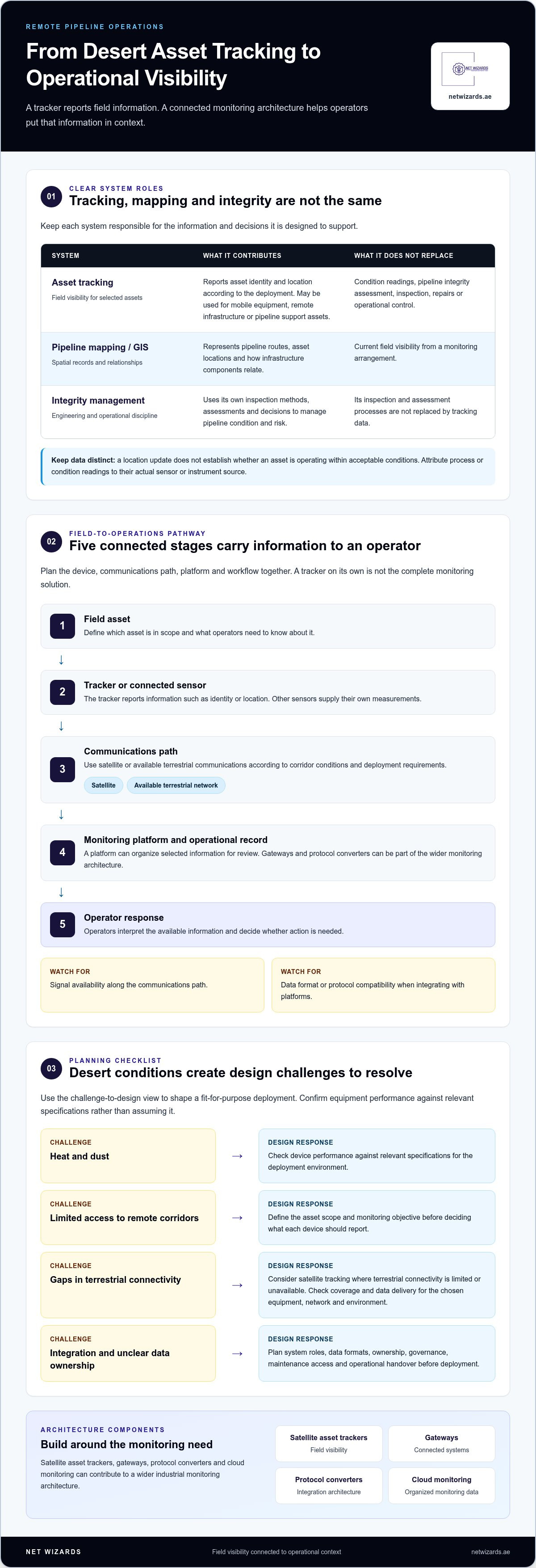
A desert pipeline asset tracker is one component of a remote monitoring arrangement. It provides field visibility for selected assets, such as their identity and location, and can form part of a wider system that carries information to an operations team. Its role depends on the deployment: a tracker assigned to a service vehicle serves a different purpose from monitoring fixed infrastructure along a pipeline corridor.
Tracking is not a substitute for field inspection or pipeline engineering. A tracker does not independently inspect equipment, diagnose pipeline integrity, make repairs or control infrastructure. Its value is in supplying information that operators can interpret alongside other records, telemetry and procedures. The broader principles are described in Remote monitoring and control systems, where equipment and communications form part of a system for observing remote operations.
Basic data path
Field asset → tracker or monitoring device → communications path → monitoring platform → operator
This sequence is a starting point, not a complete design. The tracker supplies information from the field, communications carry it, a platform presents or processes it, and operators decide whether action is needed. Keep each element’s role clear: a location record is not a condition reading or an operational instruction.
Which pipeline assets can a tracking system cover?
Deployment scope depends on the assets and the questions operators need to answer. A plan might include mobile inspection or maintenance equipment, remote infrastructure such as pump-station assets, and other pipeline support assets whose location or status matters to operations. Define the asset register and monitoring objective before deciding what information each device should provide.
- Identity and location: which asset is being observed and where it is reported to be.
- Condition and process telemetry: measurements from relevant sensors or instruments, such as equipment condition or process data.
These data categories can be brought together for operational use, but they are not interchangeable. A location update alone does not establish whether a pipeline or asset is operating within acceptable conditions.
How tracking differs from pipeline mapping and integrity management
Pipeline mapping represents routes, asset locations and relationships in a spatial record, often maintained through GIS. It helps users understand where infrastructure is and how its components relate. Tracking adds field visibility through a monitoring arrangement, providing current information about selected assets rather than only showing their recorded positions on a map.
Integrity management is a separate engineering and operational discipline. It relies on its own inspection methods, assessments and decisions to manage pipeline condition and risk. Tracking can contribute context, but it does not replace those processes. Keep records aligned, define which system owns each data type, and make the limits of tracker information clear to the people who use it.
How a desert pipeline asset tracker moves field data into operations
A desert pipeline asset tracker supports operations only when its field information can travel through a defined communications path and reach a system operators use. The architecture connects the asset and tracker to a network, a monitoring platform and an operational workflow. Each has a different responsibility. Plan them together so field information arrives in a usable form instead of treating the tracker as a standalone solution.
Satellite tracking is relevant when terrestrial connectivity is limited or unavailable at a remote asset. It provides a communications option for those conditions, but coverage and data delivery depend on the selected equipment, network and deployment environment. Design around the actual corridor and operational requirements. Do not assume one communications method will serve every location or asset.
Illustrative field-to-operations architecture
Field asset → tracker or connected sensor → satellite or available terrestrial communications → monitoring platform → operational dashboard or asset record → operator
Potential constraints: signal availability along the path; data format or protocol compatibility at platform integration.
What the tracker reports and what the platform adds
The tracker supplies information associated with the device and asset, such as identity or location, according to the deployment. Keep this information distinct from readings generated by other sensors or control systems. For example, attribute a pressure or temperature value to its source rather than assuming it comes from a location tracker.
An Industrial-grade IoT Cloud Platform can provide a shared environment for organizing monitoring data from connected equipment and systems. It adds context by bringing selected information together for review, but it cannot create measurements that field devices have not supplied. NET WIZARDS’ industrial monitoring capabilities include satellite asset trackers, gateways, protocol converters and cloud monitoring, which can be planned as parts of an end-to-end architecture.
How tracking data can connect with existing operations
Integration planning should identify where tracking information needs to appear and how teams will use it. A dashboard may need asset identity and location, while an asset record may need a reference linking that information to the correct equipment. If operators rely on existing operational or enterprise systems, define the required data fields, ownership and exchange method before implementation.
Protocol compatibility is an architecture requirement, not an automatic property of every device or platform. Map the interfaces between the tracker, communications equipment, gateways, protocol converters and receiving systems. A mismatch can prevent data from being interpreted or routed as intended. The satellite tracking for remote assets guide offers more context on where satellite tracking can fit.
- At the field layer: identify the source and meaning of each data item.
- Across communications: account for connectivity limitations and the route data must take.
- At integration points: define compatible formats, destinations and operational ownership.
These decisions help prevent field visibility from becoming isolated from response workflows. For project-specific tracking and monitoring architecture, discuss your system requirements with NET WIZARDS.
Desert pipeline tracking challenges and the design trade-offs
A desert pipeline asset tracker must operate within a system shaped by remote locations, environmental exposure, communications availability and integration requirements. Heat, dust, distance and limited site access affect design decisions, but they do not establish a device’s performance rating. Assess conditions at the intended installation points, then align equipment selection, communications and maintenance plans with the operating environment.
The challenge is not simply collecting field data. Teams need to know what can interrupt observation, how an interruption will be recognized, and what practical response should follow. Use the challenge-to-design view below to make these dependencies explicit before deployment.
Field challenge → operational effect → design response
- Remoteness: Site visits require planning. Define which assets need remote visibility and how field access will be maintained.
- Heat and dust: Exposure can affect device placement and installation choices. Assess site conditions and select equipment suited to the project environment.
- Communications gaps: Data may not travel consistently. Evaluate satellite, cellular and local-network options against coverage, infrastructure and data needs.
- Disconnected systems: Field information may not reach operational workflows. Define data formats, system interfaces and ownership before integration.
Environmental exposure and access to remote assets
Site conditions should inform mounting location, enclosure requirements, power arrangements and installation methods. Do not assume a device is suitable for heat, dust or other exposure without reviewing its stated specifications against conditions at the installation point. Placement should also account for whether technicians can reach the equipment for inspection, servicing or replacement.
Include maintenance access in both the architecture and the operating plan. Define who is responsible for field checks, how access is coordinated, and how maintenance activity is recorded. This supports planning across the deployment lifecycle rather than treating installation as the final design decision.
Connectivity gaps, data continuity, and integration
Distance, terrain and available network infrastructure shape communications choices. Satellite connectivity can support remote locations where terrestrial networks are limited, while cellular service depends on usable network coverage. Local networks may suit assets connected to an established site network, but they also depend on that infrastructure. Each approach has different deployment requirements, so none is suitable in every situation.
Set expectations for how the system behaves when a link is unavailable. Decide which information is operationally necessary, how teams will identify missing or delayed data, and what alternate procedures apply. Then map the communications path to the receiving platform and operational systems. A working field link alone does not resolve incompatible data formats or unclear ownership.
For procurement teams assessing system fit, the enterprise satellite asset tracker buying guide provides a related framework for evaluating satellite tracking within an operational deployment.
How to plan a pipeline asset tracking deployment
A deployment plan should start with operational decisions, not a device count. Identify which assets need visibility, who will use the information, and what action it should support. Then work through the sequence below, documenting assumptions and responsibilities at each stage. This gives teams a practical basis for scoping a desert pipeline asset tracker without relying on generic performance targets.
- Build the asset inventory. Record asset identifiers, types, locations, operational importance and existing information sources. Separate mobile assets from fixed infrastructure, and note where records need reconciliation before deployment.
- Define users and decisions. Identify the teams that need the data, such as operations, maintenance or asset management. For each use case, state the decision or workflow the information supports. Distinguish essential requirements from possible future extensions.
- Specify the information required. Define which records or measurements each use case needs, where each item originates, and how teams will interpret it. Avoid collecting data without a clear operational purpose.
- Assess sites and communications. Consider installation conditions, maintenance access, power arrangements and available network options at relevant locations. Select communications as part of the end-to-end architecture, based on site conditions and information needs.
- Map integration and ownership. Identify how data will relate to asset records, monitoring platforms, dashboards and other operational systems. Assign responsibility for data quality, device maintenance, access permissions and operational response.
- Test, hand over and review. Validate the agreed data path and interfaces, train relevant users, document operating procedures and transfer responsibilities. Schedule operational reviews to assess whether the deployment still supports its intended decisions as assets or workflows change.
Define assets, users, and operational decisions
Make each monitoring objective specific enough to guide system design. For example, if a team needs to locate a mobile maintenance asset, define which identifier links the field device to the asset register and which users need the location information. If the objective concerns a fixed remote installation, identify the visibility required and how it fits the team’s existing workflow.
Keep the initial scope focused. Document optional expansions separately so they do not obscure the data, interfaces and responsibilities required for the first operational use.
Plan communications, integration, and ongoing ownership
Compare communications options against actual site conditions and the monitoring architecture, then map each interface from field device to receiving system. Specify who maintains identifiers and records, who handles device issues, and who decides how to respond to operational information. Clear ownership helps prevent usable data from becoming unmaintained or disconnected after handover.
Deployment workflow
Use case and asset inventory → requirements and ownership → site and communications design → system integration → verification and handover → operational review
Success measure: agree acceptance criteria with operational stakeholders before implementation. Criteria may address whether required assets are represented, whether data reaches its intended destination, and whether designated teams can use it in their workflow. Set project-specific requirements rather than assuming universal benchmarks.
NET WIZARDS satellite asset tracking within an industrial monitoring architecture
NET WIZARDS L.L.C supplies satellite asset trackers as part of its remote monitoring and tracking systems. These trackers support continuous real-time monitoring of high-value mobile and remote equipment, giving operations teams visibility beyond fixed sites. NET WIZARDS L.L.C has 20 years in business and can plan satellite tracking alongside gateways, protocol converters and an Industrial-grade IoT Cloud Platform.
This system-level approach helps teams plan beyond the tracker itself. A gateway or protocol converter can support communication between equipment and receiving systems, while the cloud platform can organize information for monitoring. Each component has a defined role. The appropriate configuration depends on the assets, interfaces and operating requirements, rather than a standard design applied to every pipeline.
Industrial monitoring architecture
Remote asset and tracker → communications path → gateways or protocol conversion, where required → cloud monitoring → operational users and workflows
When an end-to-end industrial approach is relevant
Coordinating field devices, communications and monitoring platforms helps teams plan for information gaps between remote assets and operational workflows. With suitable data and processes, a connected architecture can support operational efficiency, maintenance planning, energy optimization and safety-related awareness. These outcomes are not automatic: teams need to define the information required, how it will be interpreted and which operational decisions it should inform.
Architecture should follow the project. A deployment focused on locating selected assets may have different requirements from one that also brings sensor or automation data into a shared monitoring environment. Define interfaces and responsibilities clearly, then select components that fit. This keeps the system aligned with current operational needs while allowing teams to assess future extensions separately.
How in-house engineering supports project-specific integration
NET WIZARDS L.L.C’s industrial capabilities include Industrial IoT sensors, gateways, and protocol converters, pipeline and pump-station automation, and cloud monitoring. Its in-house R&D centres in China and Taiwan support custom hardware and software development for project-specific engineering. Pipeline and pump-station automation is a separate industrial capability, not a feature attributed to the Satellite Asset Trackers.
Integration planning can bring these capabilities into view together. For example, a project team can define which asset information belongs in tracking, which readings come from other field equipment, and how relevant data should move through selected interfaces to monitoring systems. Keeping those sources distinct preserves data context and clarifies each component’s role in the operational workflow.
A practical next step is to frame the requirement around assets, communications, system interfaces and intended operational use. NET WIZARDS L.L.C can align the tracking discussion with the wider industrial monitoring architecture, with the configuration shaped around the project rather than a one-size-fits-all design.
Set a Clear Direction for Your Deployment
Move from planning to a defined project decision by documenting the operational problem the deployment must address, the assets in scope and the teams responsible for acting on the information. This gives stakeholders a practical basis for evaluating a desert pipeline asset tracker within the broader operating environment instead of judging it as an isolated device.
Before implementation, align technical and operational owners on the intended data use, system interfaces, maintenance responsibilities and criteria for reviewing whether the arrangement meets its purpose. A disciplined starting scope helps teams manage complexity and make later extensions deliberate, based on operational need.
A well-planned deployment gives remote pipeline teams a stronger foundation for informed decisions. NET WIZARDS can discuss how satellite tracking fits your project requirements and wider monitoring architecture.
Define your requirement clearly and take the next step with NET WIZARDS.
Frequently Asked Questions
What does a desert pipeline asset tracker do?
A desert pipeline asset tracker helps teams associate a selected asset with field information used in operations. Before rollout, create a consistent identifier convention and match each tracker reference to the corresponding asset record. For example, replacing or relocating a device should prompt an update to that association. This data-control practice helps prevent teams from acting on information tied to the wrong vehicle, installation or support asset.
How does satellite asset tracking work for remote pipeline assets?
Satellite tracking carries information from selected remote assets through a satellite communications service into the receiving arrangement. During deployment acceptance, verify that the information displayed by the operational system matches the intended asset and location. Record which locations and operating conditions have been assessed, then make those limits clear to users. This gives teams a basis for interpreting field information without assuming uniform service everywhere.
Can a pipeline asset tracker monitor pipeline condition?
A tracker alone should not be treated as proof of pipeline condition. For condition-related decisions, document the source of each reading, the instrument or system responsible for it, and the review process that gives the reading operational meaning. A data dictionary can define units, timestamps, asset references and measurement sources. This helps staff distinguish tracking records from condition information when reviewing combined operational displays.
What challenges affect asset tracking in desert environments?
Remote sites can make installation and later servicing more difficult, while heat, dust and connectivity availability may influence equipment placement and operating procedures. Turn these concerns into deployment records: identify the relevant site condition, its effect on installation or use, and the team responsible for follow-up. Include a maintenance access plan and record site-specific limitations so field and control-room teams share the same expectations.
How should operators choose between satellite and terrestrial connectivity?
Start by defining how quickly information needs to be available for the intended operational decision. Then compare communications arrangements at the actual asset locations, considering the infrastructure each requires and what users should do during an interruption. Document which assets use each path and who monitors its operational status. This makes the choice specific to the deployment instead of relying on a general assumption about satellite or terrestrial service.
Does asset tracking replace GIS or pipeline asset management?
No. To keep tracking records useful alongside GIS and asset-management information, define which system owns each field, such as the permanent asset identifier, mapped location or current tracker association. Establish how teams record asset transfers, replacements and retirements. These controls reduce conflicting records as equipment changes and help users trace a field update to the correct asset without treating separate systems as interchangeable.